This post is a continuation of Safari to Kenya – Amboseli to Samburu that ended with us leaving Samburu National Reserve on the main highway headed west and south for the Lake Nakuru area with David, our guide for the next few days.
On the Road to Lake Elmenteita (Tuesday, March 8)
To recap, we had a pleasant sojourn at the Elephant Bedroom Camp situated on the bank of the Ewasa Nyiro river and within the Samburu National Reserve north of the equator. We had seen various species of animals to be found only north of the equator (Grevy’s Zebra, Reticulated Giraffe, Oryx etc.) and had encountered numerous lions and a pair of Cheetah on a kill. We were quite overwhelmed by what we had seen yet, strangely, thirsty for more! When it came right down to it, we were just beginning our Safari, and had plenty to see.
While we had seen plenty of animals in their natural habitat, we hadn’t seen a few yet – the Rhino stood out on that list. Nor had we seen much of the country, having flown over most of it – flying is great for saving time, but I find you completely lose perspective of a different kind by flying – everything you fly over is reduced to two dimensions. Throughout my childhood in India, we took trains everywhere. You watch the landscape unroll before your eyes at speeds that we humans can process. You see a man with a bullock cart headed for market with a load of something in the back (you may never find out what, but that’s part of the charm); a group of women headed back from the local well carrying water in large clay or metal pots, kids running around and playing while they work; a family on a scooter, child in front of Papa with Mama sitting demurely on the back, side-saddle; the sun setting over palm trees with a sandy beach in the distance; the sudden rocky outcrop with massive boulders probably forged a billion years ago in some volcanic activity. It is fun! This is what I hoped to achieve in a small way on the drive down from Samburu to Lake Elmenteita – to experience a part of Kenya at a slower pace and see how people really lived outside of the cities. And I was looking forward to seeing the Great Rift Valley, something I had read about as a child.
As David drove onto the highway, he asked us to fasten our seatbelts and told us, “We can’t go over 80 km/hour; the engine is speed governed.”. I was a little surprised (not unhappy at all) and asked him why. He said that commercial vehicles (our 4×4 qualified as one in Kenyan law) had speed-governors that prevented them from going over that speed. If these were removed, and you were caught doing a higher speed, you could lose your job! I responded with, “No issues going slow, David!”.
As he drove, we asked David to tell us a bit about himself. He said he was married and had a young daughter. His wife taught in a local school in his hometown, but they maintained an apartment in Nairobi so the family could be together in either place. David’s job took him all over the country and it was quite normal for him to drive to Samburu or the other parks and conservancies around the country and guide clients. He worked for Gamewatchers and generally liked the firm.
In return, we told David a little more about ourselves and how we ended up living in New Jersey. Later, we shared photos of snow in NJ in the depths of a blizzard, something that David had heard of but not seen!
The road wended its way south toward Mount Kenya. It was a single lane in either direction but widened to 2 lanes on up-slopes to permit faster traffic to overtake slower trucks (and our speed-governed 4×4). It was a modern highway that periodically had speed bumps to slow traffic down as it approached habitation. We passed through a few villages and the periodic market set-up on either side of the highway. There were women selling potatoes and onions in what looked like 5-pound sacks or bags under the shade of trees beside the road. David told us that the potatoes were inexpensive and high-quality – farm to table food!

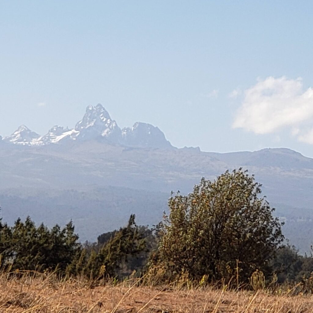
The terrain changed as we headed further south with a slight but steady rise in the land. Out in the distance, Mount Kenya became visible as we crested a rise. Soon, we hit a point where the road headed more west than south and the turn off for the town of Meru appeared – we speculated that Jennifer, from Elephant Bedroom Camp, would probably have taken that turn to go home after her week at the Camp. After the turn off, we were soon well and truly in hill country. It was very beautiful with tea and coffee plantations, greenery, and the massive prominence of Mount Kenya in the background. I was reminded instantly of Kalimpong in the northern part of West Bengal state in India, or even parts of the Garhwal Himalayas. The land had the same feel to it. A few minutes later, we had a wonderful view of Mount Kenya. I asked David if we could stop to take some pictures and he said, “Sure!”. So, we stopped, walked over to the chain link fence demarcating Mount Kenya National Park, and took some photos.
David told us that this area of Kenya formed part of the so-called White Highlands; the erstwhile British colonial government prevented native Kenyans from owning land here. I filed away this nugget of information for future study as he drove on.
| At the turn of the 20th century, the Kikuyu and Maasai tribes owned the land in this area. The pastorally-inclined Maasai used the plains over an elevation of 5000 feet to graze their cattle. On the other hand, the Kikuyu were agriculturalists, practicing “shifting cultivation” at the foothills of Mount Kenya, the Aberdare range, and the surrounding hills. A smallpox epidemic, drought, and a cattle disease resulted in the Maasai ceding lands to the British. Meanwhile, a famine caused the Kikuyu to take refuge with relatives elsewhere, leaving the land temporarily unoccupied. This resulted in the British settlers characterizing the land in this area as uninhabited! Between 1902 and 1930, many European settlers moved in and acquired the land. Colonial law permitted the land in this area to owned and managed only by these settlers. Later, in the early 1950’s, this land grab led in part to the infamous Mau Mau rebellion that was crushed by the British in 1956. But this probably convinced the British that there was need for reform in Kenya, which attained independence a few years later in 1963. |
By now it was about 9:30am and we had been driving for almost 2 hours. David said we’d drive past the town of Nanyuki and then stop for a rest break. Indeed, soon we hit the main street in Nanyuki a busy market town of about 50,000 people. David navigated his way through town and a few minutes after we hit the outskirts, we were back on the highway again. As we drove, I spotted an unobtrusive sign indicating we were at the Equator! Excitedly, I asked David if we could stop to take a photo. He said, “Don’t worry! We’ll cross it again a couple of times and we can stop then.”.
At about 10.15am, we saw an airstrip on the right of the highway and David pulled off the road and to a closed gate with a guard hut on the inside. The staff opened the gate and let us in and with that, we were at our promised rest stop at the Nanyuki airstrip. We halted in the parking area and then headed to a lovely, inviting building with a café named Barney’s Bar and Restaurant. A few customers were at tables sipping at their lattes (more likely tea!) or eating pastries of some kind. The clean and well-maintained facilities were at the back and having used them we looked at the offerings in the café. Not particularly hungry or thirsty we decided to forgo refreshment and headed back to the 4×4. David was off chatting with the gate guards and soon came back peering at his phone with a look of puzzlement on his face. We asked him if everything was ok. He responded that the airstrip had started to charge 100 Kenyan shillings for parking, but would accept only M’Pesa, which as I learned was the popular, electronic cash transfer system used widely across Kenya. Unfortunately, there was some glitch with the system, and it took David a few minutes of cajoling the app on his phone to complete the transaction. (Interestingly enough, the staff were not equipped to accept cash. It seems that Kenya has converted to a largely cashless society well before the USA and many other countries!)
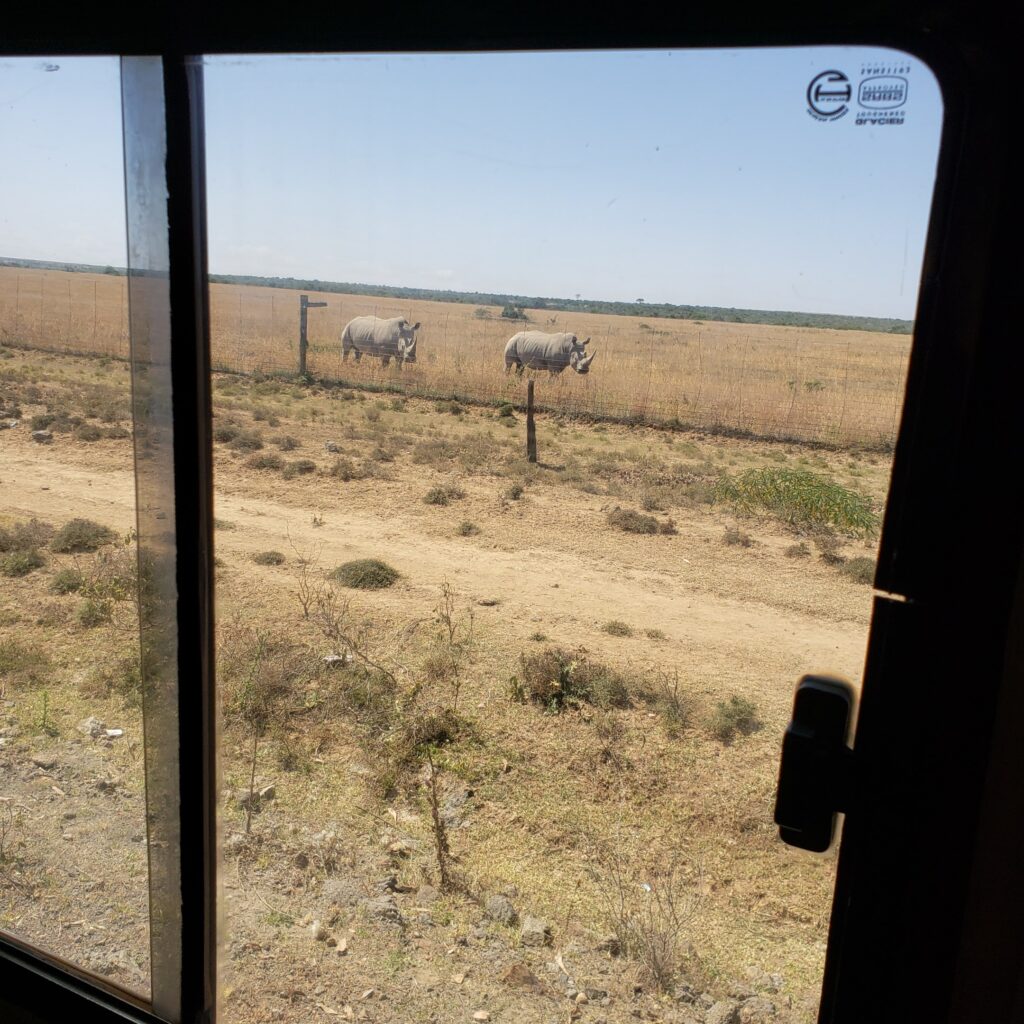
At 10.30am we back again on the highway. In a few minutes at the small town of Naro Moru, we made a sharp right turn off the highway onto a local road and headed west. About 10-15 minutes past the town, we saw road signs welcoming us to Lakipia County. There was a large, fenced property on the left side of the road which went for miles. David said, “Rhino ahead!” and slowed down to pull over to the side of the road. That was when we saw our first Rhino, the last of the big five that we had yet to see! There were a pair of Rhino right beside the fence grazing on the tall but dry grass.
We watched them for a couple of minutes and then got going again. David was good at keeping us on schedule! The road wended its way west past the Aberdare range to the south. We passed through more villages and small towns. About 11.30am, we joined the Nyeri-Nyahururu Road, also known as the B5 highway, and continued north and further west. Just before noon, we spotted Equator Point and David slowed and then stopped at what looked like a souvenir shop with the Equator between the shop and the highway. We alighted and were immediately besieged by a man who insisted on showing us how the Coriolis force affects water direction when draining south of or north of the equator! We listened and watched a little, took a few pictures and then went into the shop. There were numerous curios, some of which may have been worth buying, but we weren’t particularly interested in shopping. The man then gave us certificates after recording it in a hand-written logbook, but these unfortunately he wrote the wrong date on the certificates! David insisted on having them corrected and we went back to the store to do so.

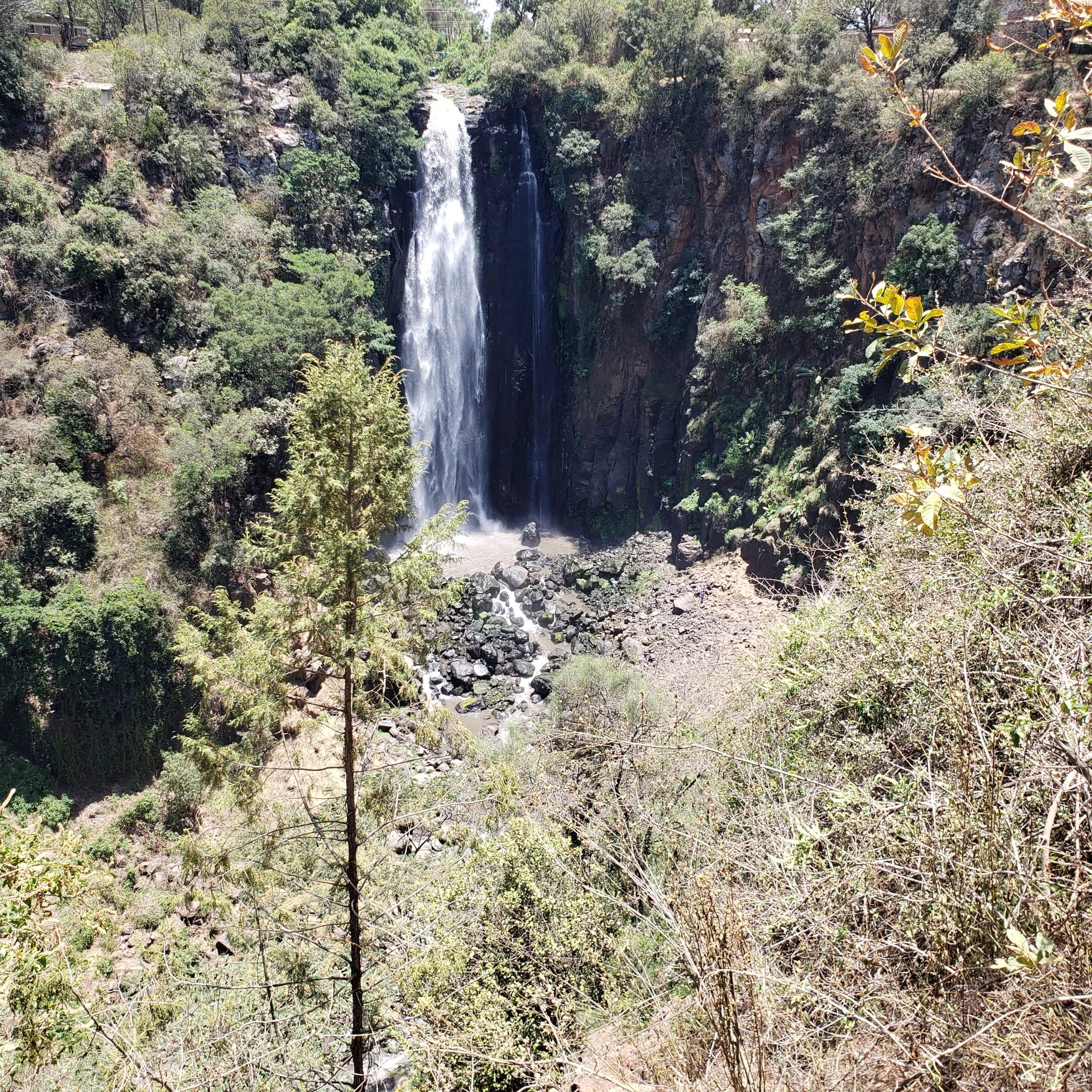
This rigamarole cost us 10 minutes and, 5 USD poorer, we headed back to the vehicle for the short drive to Thomson Falls at Nyahururu. About 20 minutes later, we arrived at the falls, parked, and paid the entrance fee. We then walked into the park and were accosted by a few people carrying some trinkets and a few chameleons on their shoulders! One of them promptly placed a chameleon each on my shirt and on Iris’! This slow-moving creature wended its way up until I could barely see it out of the corner of my eye, causing some small agitation! He was a beautiful specimen, but not one that I cared to have on my person. I asked the man to remove it and he did so after a picture or two.
We then surveyed the falls which were quite beautiful. They fell about 200 feet into a steep gorge and formed part of the same Ewasa Nyiro river that we had seen in Samburu National Reserve. We spotted some people at the rocks around the pool into which the fall debouched and asked David about climbing down. He recommended that we not do it since the path was pretty steep and quite slippery with moss and such.
We spent a few more minutes taking photos and walked around the park before heading back to the vehicle.

It was nearing 1pm and we had planned to lunch at a resort in Nyahururu run by the Panari Group. In a few minutes, David drove us there and we entered the beautifully manicured lawns of a well-maintained resort. We walked through the lobby to a restaurant at the side of the building. The restaurant was right beside a lovely courtyard with a lawn and flowers bordering the lawn. However, we elected to sit inside in air-conditioned (although we were up at about 7000 feet, it was quite warm) comfort. The hostess seated us, and we decided to opt for the buffet lunch – some wonderful salad, continental and Indian offerings, and tiny plates with dessert that all looked very appetizing. We ordered water and some sodas to wash down the meal and ate a very satisfying lunch.

The large room in which we were seated (it could comfortably hold a hundred people) was mostly empty when we started the meal until about 1:45pm when a group of perhaps 50 people arrived together. They were at the resort for a convention of some kind and the calm atmosphere suddenly changed. Since we had finished, we paid, headed out and looked for David who had opted to eat the lunch that had been packed by the Elephant Bedroom Camp in Samburu.
We set off again at about 2pm. In a few minutes, the road started to snake its way up a large hill with a few switchbacks/hairpin bends. At 2:30pm, David stopped at Subukia Viewpoint and I had my first real view of the Great Rift Valley. And what a view it was! We were looking down on the valley which was extremely broad – we couldn’t really see the opposite side. Trees, arid patches, lakes, grass, farmland, and the like were visible from the viewpoint that is at an elevation of about 6600 feet. There were houses dotting the landscape near the farms and you could see the road making its way across the valley. A very pretty sight indeed. And not just pretty. I was probably not far from the place where our species first walked on earth. It may have been a little south or a little north of where I was, but chances are that our ancestors originated somewhere in, or in the vicinity of where I stood at that moment. Quite a solemn, yet exhilarating thought, you will agree.


We got back on the road after a few minutes and made our way down to the floor of the valley. As we went down the hill, we went past the town of Subukia and crossed over the equator again, heading south this time. We were now in Nakuru County, having crossed over from Lakipia County. Once on the valley floor the road wended its way through the farmland, villages, and towns. We were heading in a mostly southerly direction and soon started to see signs of a large city ahead. Traffic started to pick up and in a few more minutes we were in the center of Nakuru, one of the fastest growing cities in Kenya. We made a turn onto the Nairobi-Nakuru Highway towards Nairobi and started to see many 22-wheelers carrying goods headed in the opposite direction. David explained that most of these trucks were picking up goods from Mombasa, the main port in this part of East Africa, and were carrying these to the Lake Victoria region in the western part of Kenya and to Uganda and possibly Rwanda (a.k.a. the Singapore of Africa). The highway is well built, but is frequently a single lane in either direction, causing faster automobile traffic to slow down behind the slower commercial traffic. We made our way East and after about a half hour we saw a large lake off to our right. David said, “That’s Lake Elmenteita”. We turned off the road to the right (people drive on the left in Kenya) and approached a gate to a compound fenced both with shrubbery and wire. A guard let us in, and we bumped our way up the dirt and gravel path to our home for the next 3 nights, Sunbird Lodge in Lake Elmenteita. It was about 4pm and we had been on the road for over eight hours.


We alighted and walked into the lobby area which had a reception counter on the front wall and a partly, glassed-in back wall with a view of the lake below us. A door in the back wall led to a few steps down to a patio that overlooked the lake. Fantastic views were to be had! We turned to our hostess to check in – she introduced herself as Naomi and welcomed us. Iris asked her if she was related to Naomi Campbell and Naomi’s deadpan response was, “My sister!”. We burst out laughing and completed our check-in formalities. We asked Naomi if we needed to be escorted back-and-forth or we could walk around the grounds at any time. She responded that they had installed an electric fence to prevent the Buffalo from getting into the compound, and that we were free to move around. We chatted a little with David and arranged to set out at 7:30am the following morning to the Lake Nakuru National Park where we planned to spend the day. David worked out a picnic lunch for us from the lodge for the next day and then headed off to his night’s stay about 15 minutes away. In the meantime, Naomi checked with us about what we wanted for dinner (they had choices up on a chalkboard in the reception area) and we then set off down a gravel path to our cottage a few yards away.
Our cottage was called Marabou, after the stork. We walked over and found our luggage – suitcases and duffel bags – already in place. After a little exploring, we settled down and relaxed before dinner. We found that the lodge had installed solar heating for the water – as a result, we had running hot water, for a change. But there was also a sign to conserve hot water in the evenings to avoid running out first thing in the morning! After finding that the front verandah to the cottage had hammocks (!) installed, Iris relaxed on those while we sipped on a cup of tea brought over by the staff. Meanwhile, I took photos from the cottage, and of the cottage itself. At about 7pm, I took some photos of the remnants of a beautiful sunset, and we then headed off to dinner.


For dinner, we opted to sit at the outdoor patio. Our server introduced herself as Caroline and efficiently got us our soup and then our main courses. Soup was fabulous as it always was in Kenya – I think it was a potato-leek, but very consistent as it was pureed, and with a hint of spice that enhanced the whole dish. The main course was average. There was some dessert that I can’t recall now.
After dinner we decided to call it a night and headed back to Marabou. We were excited about visiting the Lake Nakuru Park the following morning and Lake Naivasha (I had read about the latter when I was 12 years old in Joy Adamson’s book Born Free!) the day after. With that pleasant anticipation, we were off to bed. And with that, our long travel day came to an end.
Random Tidbits and Musings
- Lake Elmenteita was a good base for our exploration, being roughly equidistant from Lake Nakuru National Park and the Lake Naivasha area, both of which we planned to visit over the succeeding 2 days.
- We heard of numerous private conservancies in the area but didn’t research these further. Our plans were well made, and we saw no reason for deviation.
- On the drive, David told us a little bit about the 43 tribes in Kenya. He told us about the Kikuyu, the Maasai and the Samburu. He hailed from the Kamba tribe which is located between Nairobi and Mombasa. David also told us that people from Asia, particularly from India, numbered over 2 million in Kenya and were recognized as a tribe!
- We heard from David about the Kalenjin ethnic group (composed of multiple tribes) from which Kenya’s runners originate. These peoples populate the west-central part of Kenya in the Mount Elgon region. (In relation to where we were at Lake Elmenteita, it is North and West and borders the nation of Uganda.) We speculated on our drive that part of the reason why this region produced so many good runners was due to the altitude causing runners to have increased lung capacity, especially at sea-level, but that is probably only one of numerous factors.
- On the drive, we saw numerous billboards with political messages and local leaders. We heard from David that Kenyans took a keen interest in politics, and general elections (including that for the president) were scheduled for August 2022. David also told us that turnout was expected to be high as in previous elections. I learned too that in the almost 60 years since independence, Kenya has had only four presidents. When I voiced the thought that political stability had given governments the chance to implement policy effectively, David agreed but also pointed out that the elections in 2017 were turbulent and even violent at times. Note: Elections are held every 5 years on the second Tuesday in August.
(Photos can be found on this Google Photos Album while videos are at this YouTube Channel.)
To be continued…
Pingback: Safari to Kenya – Lake Nakuru National Park – Srini’s Blog